


Pre-Colonial Sydney:
The European Connection
Sydney started life as a British Penal settlement, but it could well have been a Spanish, Portuguese, Dutch or even a French city. Here we examine how the Sydney Basin first became Spanish territory, how it passed from Spanish to British control and why it became so important to the British Government that Sydney, as its first settlement on the Australian continent, be established not only when it was but also where it was. The Aborigines who occupied the area now known as the Sydney basin were aware of the exi stence of fellow Aborigines in areas beyond where they lived. Early colonial records indicate they had communication with some of them from time to time, when they traded goods and perhaps folklore at corroborees. The extent of their knowledge of the peoples and places beyond their immediate neighbours would have been very limited and there is no evidence to suggest that any of their number had travelled or explored other parts of Australia, as it was customary to stay within the bounds of their own territorial lands. But they had no knowledge that their communities were but a handful among thousands dotted around a circular planet called earth and that, beyond their shores, there were two major cultures - European and Asian - which had been developing simultaneous to theirs on the largest continental land mass in the northern hemisphere.
It was to be many thousands of years from the time that the Europeans first theorised that na south land such as Australia must exist, before it would be discovered and the two cultures would meet. During the 16th century, the Europeans, led by the Spanish and Portuguese had driven the Moors out of southern Europe. They began flexed their political and commercial muscles against the Muslims so as to take over the major trade routes between Europe and Asia. The discovery of the Americas in 1492 by Christopher Columbus, a Genoese seaman living in Spain, led Spain to develop its trade route to the Indies by sailing west across the Atlantic via the New World. To his dying day, Columbus believed the north coast of Cuba to be that of China, that the island of Haiti, which he discovered, was part of Japan and that the delta of the Orinoco River, which he encountered on his third voyage of discovery, drained into Marco Polo's great south land or one associated with it. Portugal was left with no other choice but to attempt to reach the Indies by sailing around Africa. Batholomeu Diaz became the first to round the southern tip of Africa in 1488, Vasco De Gama landed in India 13 years later and established a trading base there from which the strategist Affonso Albuquerque would quickly build Portugal's A ]siatic empire, crushing all who dared to oppose him. With the landing of Cabral in Brazil, the time of the great colonial wars in the oceans had begun. So fierce was the competition between Spain and Portugal, Pope Alexander VI had to arbitrate; he drew a line of demarcation through the then known world, allocating the western hemisphere to the Spaniards and the east to the Portuguese.

The north-south line finally agreed upon and established at a Treaty in Tordesillas in 1494 was set at 370 leagues west of Cape Verde Islands. In principle the treaty followed the papal bull issued in 1493, however wit shifted the demarcation line away from where the Pope ruled it should be, thereby giving Portugal a claim to Brazil. The continuation of this line around the globe and into the Eastern Hemisphere was to deny Portugal the right to claim of the Philippine Islands upon their discovery. Spain recognized this claim in the Treaty of Saragossa in 1529, which saw the line re-set to 17 degrees east of the Moluccas (Spice Islands) at 144 degrees. Little did anyone know at the time that these dividing lines went right through Australia, which at the time had not been discovered by Europeans. The Treaty of Tordesillas had set the line at 127 degrees east of Greenwich, which falls some 300 kilometres to the west of and parallel to Western Australia's border with South Australia and the Northern Territory. The Treaty of Saragossa moved the dividing line east to the eastern side of Cape York Peninsula, crossing the coast near Cape Melville in the north and in the vicinity of Lorne on the south west coast of Victoria and through King Island in the south. When other European nations followed the yellow brick road to the Far Eas t seeking to establish their own trading outposts, they had gone in Portugal's footsteps by going via Africa. In doing so, the Dutch came across Portugal's half of the Great South Land, which was no problem to Portugal as they were too busy making money out of the Spice Islands to worry about it. Besides, the two counties were allies.

Though they marked it as New Holland on their charts, the Dutch found nothing that interested them on the western seaboard as they too were only interested in trade and no trading possibil.ities were found. Apart from the odd shipwreck or trek ashore to replenish their supplies of fresh water, all the Dutch did was map it and keep as far away from it's reef-riddled shoreline as possible. Though a section of the yet to be charted Australian continent was in Spanish territory, Spain had shown little interest in either finding, exploring or settling the Great South Land. Ferdinand Magellen would undoubtedly have been on the look out for it in 1521 during his epic voyage around the globe but it is not known whether or not its discovery was on his adgenda. Magellan did not travel far enough west during his voyage across the South Pacific to allow him to meet up with the Australian coastline. He had set a north-westerly course for The Spice Islands immediately after rounding the southern tip of South America, believing them to be much closer to America than he found them to be. Had he stayed in the southern latitudes for longer he would in all probability have followed the route taken by James Cook some 249 years later and discovered what Cook did, which included Botany Bay and Port Jackson.
Magellan's was the first and last voyage by a Spaniard to come remotely near the east coast of Australia. The Portuguese are believed to have made at least one journey along Australia's eastern seaboard but written records of their voyages have not survived to substantiate the considerable amount of circumstantial evidence that points to a such a visit in 1524. The French had yet to follow their European neighbours into the world of colonial expansion, and the English were pre-occupied with their North American colonies which, by the mid 18th century, were starting to given them plenty of trouble. That is, until 19 April 1770, the day Lieutenant James Cook first sighted the Australian mainland. 1770 proved to be a momentous year for Australia, and Sydney for that matter, even though at that time it was no more than a twinkle in Australia's eye. That was the year in which Australia finally made it onto the world map, a year in which the first of a series of momentous events took place which led to the birth of the first European settlement in Australia, Sydney.
The idea of a British expedition to discover and claim the Great South Land, Terra Australis, for Britain was first promoted in the 1760s by the eminent British scientist Augustus Dalrymple who had become recognised as one of the leading scientific minds of Europe. Dalrymple, a powerful voice in Britain's Royal Society, was a firm believer in the theory that there existed a large continent, hitherto unknown to Europeans located somewhere in the region of the South Pacific. The collective of his thinking, experience and research pointed to an imbalance of the known oceanic mass with the known land mass in the southern regions by a ratio of about 8 to 1, which indicated a large continent must exist and was waiting to be found. Dalrymple sup yported his theory with a series of maps drawn in the French town of Dieppe, the cartographical centre of Europe, that had been published in the mid 16th Century, along with a copy of Marco Polo's journals, all of which pointed to the existence of a rich country to the south of Java called Java le Grande. As astronomers had determined the planet Venus was to pass between the earth and the sun on 3rd June 1769, upon Dalrymple's suggestion, the Royal Society determined to make a world observation of the event, and use it as a means of offsetting the expense of an expedition into the South Pacific after the observation had been completed, so as to prove Dalrymple's theories correct. One viewing station was to be from an island (Otaheite) in the South Pacific.
Dalrymple put forward himself as leader of the expedition, and requested the Admiralty provide a ship. They agreed, however when Dalrymple insisted that he have command and control of the vessel, the Navy said ÒNo, we cannot have a civilian in charge of a naval vessel' and appointed a 40 year old officer by the name of James Cook to the task. Dalrymple declined to participate in the expedition under the circumstances, a decision that was no doubt influenced by Cook's belief that there was no south land and that the expedition would prove it to be so. The ship chosen for the expedition was the Earl of Pembroke, a former Whity-built east coast collier that was refitted for the expedition and renamed Endeavor Bark. It was purchased at a cost of £2,840/10/11 with a further £2,294 being spent on alterations, additions and spare parts. Although only 32 metres long and measuring 3 metres at her greatest width, it was roomy, sturdy and broad-bottomed and proved to be well able to withstand the rigors of the voyage. Cook would have been very familiar with that type of vessel, which was in common usage in the area where he grew up, and there is every chance that he may have already been familiar with the Earl of Pembroke.
 The ship's company included the accomplished botanist, Joseph Banks (right), who scored his berth and got to hand pick the scientists who were to travel with him by offering £10,000 to equip the scientific party. Chosen by Banks to accompany him were Charles Green, Assistant Astonomer at the Greenwich Observatory; eminent Swedish scientist Dr Carl Solander, one-time pupil of the great botanist Linnaeus; Swedish naturalist Herman Spring; two artists, Alexander Buchan (landscape) and Sydney Parkinson (natural history); cartographer John Reynolds; and two footmen and two negro slaves who were Banks' servants. Only the footmen, Banks and Solander survived the voyage. Banks' two greyhounds also joined the livestock aboard, which included a goat that had already circumnavigated the globe l with Samuel Wallis who had commanded the frigate Dolphin on an expedition of discovery to Tahiti in 1766.
 Cook continued northward, naming features, always searching for good harbours and maintenance materials for his ship and crew. The further north he travelled, the more difficult navigation became. Cook was being funnelled into the narrowing channel between the mainland and the maze of reefs of the Great Barrier Reef system. He continued sounding and naming features he observed before the Endeavor grounded on a reef on 10th June. Cannon, gear and ballast were jettisoned and after 23 hours, the Endeavour was floated free. A piece of coral was wedged into a hole in the hull of the vessel and a piece of sail was strapped under the Endeavour's hull to minimise the entry of water. She which was eventually brought to safety at the mouth of a river which Cook named after her. The Endeavour was beached and during a seven week sojourn, the hull was repaired. When the Endeavour finally set sail, it escaped away from the mainland and into the sea beyond the Reef. On Tuesday, 21st August 1770, Cook reached the peninsula tip which he named York Cape in honour of His late Royal Highness the Duke of York. The next day he went ashore of an island in the York group (Possession Island) and proclaimed the lands he had discovered for the King. It was with great relief that Cook passed out of the reef and into Torres Strait towards the coast of New Guinea, then west along the southern coast of Java and around the west end of the island into Batavia. Three months were spent in Batavia, which was rife with disease and general unhealthiness, conditions there no doubt contributed to the increased loss of life on the voyage home. Nicholas Young was first to sight Land's End and three days later the Anchor was dropped in the Downs, 13th July 1771.
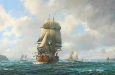
 Lieutenant George Vancouver (right), who was involved in the initial negotiations, was the British envoy sent to Nootka Sound to implement locally the terms of the Agreement with Spain. Once the job was completed, he was immediately dispatched to the South Pacific to carry out further exploration and though not publicly stated, to tie up the loose end relating to the sovereignty of the rest of the Australia. The western slab of the Australian continent still bore Holland's name, it had been claimed by both the Dutch and the French but was in Portugal's half of the world according the Treaty of Saragossa. Under the Nootka Sound Convention, however, it was still up for grabs. Before the second day after his arrival off the Australian south coast was over, Vancouver had already entered and named the first sheltered bay he found (King George Sound), had gone ashore and claimed the western part of Australia for King George III. Mission accomplished; the whole of Australia was now British territory. His major task now accomplished, Vancouver spent the next three years exploring the coasts of New Zealand, Tahiti, Hawaii and the west coast of North America. All that was left for Britain to do to secure its claim on Australia was to colonise it. This they had already begun to do with the founding of Sydney two years earlier.