


Watsons Bay Trip Guide

The Eastern Suburbs of Sydney are located between Sydney City and the Pacific ocean coastline. Many of thse suburbs are waterside, and line the harbour's southern shore from the city to Sorth Head. They boast some of Sydney's finest views, and most expensive houses. This ferry trip not only follows a foreshore lined with multi million dollar mansions, it also gives you close up views of such Sydney icons as the Sydney Opera House, Garden Island Naval Base and Fort Denision, before dropping you at one of Sydney Harbour's most interesting destinations - Watsons Bay. The trip deserves a full day, but can be done there and back with a bit of sightseeing along the way in half a day if your time is limited.
Click on or tap a blue heading to read the description and view photographs. Click or tap again to hide the description.

Bennelong Point
Once a small island off what the First Fleet colonists called Cattle Point, Bennelong Point is today the site of one of the world's most well known 20th century buildings - The Sydney Opera House . When the first fleet arrived, cattle were brought ashore here. It was soon developed as a fort to protect the infant colony on Sydney Cove to its immediate west, then as a tram station before the opera House was built.

Sydney Opera House
The Sydney Opera House is one of the world's iconic buildings of the 20th century and one of the few buildings to be erected in that century that is instantly recognisable in just about every country in the world. It's a building some people travel half way around the world to see, and marvel at its shape and setting. That it has one of the most inadequate, ill-designed opera theatres every built is irrelevant to all but those who use if for the function it was built for - what matters to the rest is that it represents Sydney, and indeed Australia, to many people of the world.

Fort Denison
Fort Denison is one of the most visited and photographed islands on Sydney Harbour. In 1788 a convict named Thomas Hill was sentenced to a week on bread and water in irons on what had originally been given the descriptive name of called Rock Island. It came to be known as Pinchgut. The fort which covers the island was built in the 19th century to help protect the town of Sydney from naval attack. Fort Denison can be visited by ferry from Circular Quay.

Farm Cove
Between Bennelong Point and Mrs Macquaries Point is Farm Cove, so named because the young colony of Sydney planted its first crops here beyond the cove in 1788. Today, Sydney Botancial Gardens circle the cove. Featuring gardens, grassed areas and gently sloping paths, it is a peaceful haven from the hustle and bustle of the traffic and noise of the city just a block away.
Facilities: picnic areas, restaurant, takeaway snack bar, visitors centre, gardens shop.
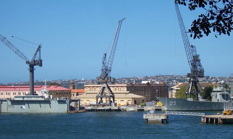
The first ferry stop is Garden Island.
Woolloomooloo Bay
Garden Island
Situated to the east of the Sydney Central Business District is Garden Island, which, as its name suggests, was once an island, but is not connected to the mainland via the Captain Cook Graving Dock. Garden Island has been associated with the defence of Sydney and eventually Australia, since the first fleet of convicts arrived in 1788 and built a fort there. It is today the home base for the Royal Australian Navy fleet, and consequently, access to Garden Island is restricted. A naval museum is open to the public and affords easy access to ferry travellers.

Clark Island
This small island off Darling Point is named after a First Fleet Lieutenant of the Marines, Ralph Clark, who in November 1789, planted a private garden of corn, potatoes and onions there. The island has remained pretty much as Clark had left it, being declared a public reserve in 1879.

Darling Point

Double Bay
The suburb of Point Piper occupies the small peninsula which separates Double Bay from Rose Bay.

Rose Bay Wharf
Rose Bay is an affluent locality on the shores of Sydney Harbour in Sydney's Eastern Suburbs. Located 7 km to the east of the Sydney central business district, Rose Bay enjoys views of both the Sydney Opera House and the Sydney Harbour Bridge together. The ferry wharf adjoins Lyne Park, which was the site of Sydney's flying boat airport.

From 1938 until 1974, Catalina and Sunderland seaplanes landed on Sydney Harbour and berthed here, at what was Sydney's first international airport. Sea planes still take off and land there, but these days they are only joy flights. The ferry wharf stands on the very spot where Qantas Sunderland flying boats were serviced during the inter-war years.

Shark Island
Located between Rose Bay and Bradleys Head on the Lower North Shore, Shark Island offers uninterrupted views up the Harbour to the Bridge and down to the heads. Crowned by a large Gazebo on its hill, the island has picnic tables scattered under the trees and man-made grottos providing nooks with wonderful harbour views. This ferry service does not stop at Shark Island.

Vaucluse

Neilsen Park
The next two bays on the right hand side of the vessel are Vaucluse Bay and Parsley Bay. It was once possible catch a ferry to Parsley Bay, but the service was discontinued many years ago. Today it can only be reached by car, bus or on foot from Watsons Bay. It is well worth a visit; the bay has a picturesque suspension bridge, safe waters and a park for children to play in, grassed areas, picnic facilities and a kiosk, not to mention a bush walk that leads to a pretty waterfall (after rain) at the head of the small valley.

Parsley Bay

Parsley Bay
It is perhaps a blessing that Parsley Bay is overshadowed by its more famous neighbour, Watsons Bay, as this picturesque corner of Sydney Harbour is a quiet haven for those lucky enough to know of its existence and have discovered its tranquility. Though the least frequented, it is as attractive as any other bay on the South Head peninsula, and the perfect place for children to take a dip in its sheltered waters or fossick for shells and crabs on the rocks while the adults laze away the afternoon in the shade of the Moreton Bay fig trees.
Circling Parsley Bay is a rocky ridge which forms a small valley through which a small stream flows. The stream enters the valley high on the escarpment at the valley's head and cascades over rocks for some metres before winding its way through the only remaining natural strand of rainforest on Sydney Harbour's southern shores, to empty into the harbour.
Parsley Bay reserve is a 15 minute walk from Watsons Bay. After disembarking from the ferry at Watsons Bay, walk through Robertson Park, then f ollow Houptoun Avenue towards Vaucluse; a signposted laneway about 1 km from Robertson Park leads to Parsley Bay.

Watsons Bay
The ferry service terminates at Watson Bay, a charming maritime village tucked away in a pretty corner of the harbour. It is the starting point for a number of walks and activities both around the village and on nearby South Head.
Once a fishing village, Watsons Bay is now one of the must-see places for visitors to Sydney Situated on a peninsula at the the southern entrance to Sydney Harbour, Watsons Bay offers panoramic views up the harbour as well as coastal vistas on the ocean side. There are enough things to see and do here and in the vicinity to fill a few hours or a few days. Fish and chips on the grass at Robertson Park is somewhat of an institution in Sydney - and if you prefer to dine a little more upmarket, another Sydney dining institution - Doyles Seafood Restaurant - is a just over the road on the beachfront.

Robertson Park is the large grassed area in front of you as you leave the ferry wharf. It is a short walk across the park and Military Road to The Gap and Gap Bluff, where a wall of cliffs facing the Pacific Ocean offer stunning vistas both of the cliffs themselves and up the harbour to the city. The Gap is a notorious place for suicides. The Gap Lookout, to the left after reaching the cliffs at the top of the steps, offers panoramic views up and down the coast as well as up the harbour.

South Head
As its name implies, South Head is the southern headland at the entry to Sydney Harbour. A 30 minute walk from Watsons Bay village, it offers panoramic views of the heads, Manly and the lower end of the harbour, and a popular spot on Boxing Day (26th December) to watch entrance in the Sydney to Hobart Yacht Race head out to sea on their way to Tasmania.

The headland features Camp Cove, the heritage listed Horny lighthouse and lighthouse keeper's cottages, historic gum emplacements, spectacular coastal cliffs as well as numerous examples of Aboriginal rock art. On the way, walkers pass HMAS Watson, a Naval Training School, and Lady Bay, a secluded beach where nude bathing is permitted.

Camp Cove: If you take a short walk from Robertson Park through the Watsons Bay village to the end of Cliff street you will come to Camp Cove. It was here where, on the night of 25th January 1788, Gov. Arthur Phillip and a party of soldiers from the First Fleet camped during their expedition to find a more appropriate settlement site than Botany Bay, hence the cove's name. On the following day, Phillip found and chose Sydney Cove as the site for the new colony. Today a stone obelisk marks the spot where Phillip came ashore and camped. Camp Cove is used by many sailboarders and scuba divers to begin their activities. Nearby Laings Point recalls Edward Laing, the first landowner in the area who was granted 20 acres in the Watsons Bay area in 1793.

Colonial Era Fortifications: The cobblestoned roadway near the top of the steps above Camp Cove is a remnant of the original road constructed in 1871 along which military hardware was transported to the various installation points on South Head. The Inner Battery was built in 1873 and consisted of a series of gunpits and numerous lookout points on the headland from Green Point and Lady Bay. Five guns were aimed across Watsons Bay. A new Outer Battery was erected beyond the Hornby light and facing the ocean and a series of tunnels to connect the inner and outer batteries were cut.

In 1914, the guns were briefly mobilised, but never fired in anger and more bunkers were erected. One has a hand painted 1915 with an upwards pointed arrow (the defence department symbol) above it. During World War 2, a new series of tunnels were built linking HMAS Watson to a wharf used to offload military supplies at Camp Cove. These tunnels are quite deep and rather labyrinthine, their entrances today are blocked by steel doors. At the same time, a series of new observation bunkers were cut deep into the cliff face. These include one which was particularly well placed for viewing the Lady Bay nudist beach.

Lady Bay