


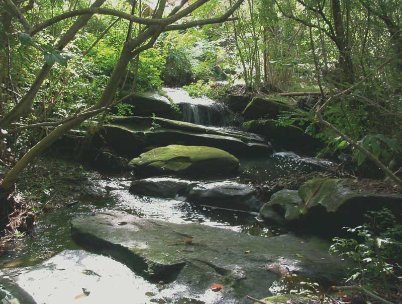
There are numerous creeks on the a northern shore of Port Hacking which pass over races and/or waterfalls on their way down the rocky hillside to Port Hacking. Extensive suburban development has reduced the flow of water in them substantially and a handful, including the creek which flows through Alcheringa Park, in Forest Road, Miranda, have been protected from further destruction by the retention of a ribbon of natural bushland around them. Alcheringa Creek flows over a small but pretty series of falls in the bushland beyond the sports oval of the reserve. The rocks at the top end towards Forest Road contain the remains of Aboriginal rock engravings which are still visible.
- Get Directions
- Get Directions
- Get Directions
- Get Directions
- Get Directions
- Get Directions
- Get Directions
- Get Directions
- Get Directions
- Get Directions
- Get Directions
- Get Directions
- Get Directions


Savilles Creek forms the north western boundary of Royal National Park in Sydney's south. A pretty watercourse which drains into the North West Arm of Port Hacking, it passes through a series of small rapids and races before tumbling over a 10 metre high falls which is quite spectacular after heavy rains. There is no direct access to the falls via a walking path but the bush around it is relatively easy to pass through so it is not difficult to reach. Drive to and park at the end of Bligh Street, Kirrawee and walk the short distance down the hill to the creek. Cross the creek as soon as possible (there is no bridge but it is easy to ford) and walk downstream for about 10 minutes to reach the falls.
Coonong Creek, which passes through the southern suburb of Gymea Bay, flows over a series of its races on its journey to Port Hacking. A walking path gives access to the reserve which surrounds the watercourse. Join the creek either at the end of Peter Place, Gymea Bay, or Valley Way off Bunarba Road, Gymea Bay.

Numerous creeks flow off the escarpment into the Woronora River valley in the vicinity of Heathcote, in Sydney's south, resulting in there being many falls and cascades in the area. Most are in bushland and therefore not easily accessible - one that is, which flows through the township of Heathcote, is on Bottle Creek. There is no path to the falls but it is accessible through bushland at the end of the appropriately named Waterfall Road, Heathcote.
E.G. Waterhouse Camellia Gardens in President Avenue, Caringbah is a peaceful oasis which features camellias, ferns and azaleas. A creek flows through the gardens and then over a small waterfall into Kareena Park at the head of Yowie Bay. The park has a short but pleasant bush walking path alongside the bay.
The vety pretty Engadine Falls, on Engadine Creek, are the closest falls in Royal National Park to a railway station. As its name suggests, that station is Engadine. To reach the falls, enter the National Park from the station entrance and take the track almost immediately to the left. The falls are less than a kilometre down the track.
Kelly's Falls is an amazing place just a few minutes drive from Helensburg. There are in fact two large waterfalls and a series of smaller waterfalls set among lush vegetation. There is seating and viewing platforms that offer some great scenery and amazing views.
Among the best features of Heathcote National Park are the waterfalls and swimming holes like Kingfisher Pool which lie on both the Woronora River and Heathcote Creek. The at-times unclearly defined track follows Heathcote Creek, passing an Aboriginal rock shelter near a tree from which a bark shield has been clearly cut before reaching Myuna Pools and its falls (below).

Alternatively, take the Myuna Track alongside Myuna Creek past rapids to a rock amphitheatre and a spectacular waterfall as well as ruins which date back to the Depression.
Location: Heathcote National Park, Heathcote, NSW

Cooper Park in Bellvue Hill is a 15 hectare reserve which comprises of picnic, recreation and sporting facilities below one of the largest remaining areas of natural bushland in the Eastern Suburbs. The creek running though the Park, which flows over waterfalls and cascades, is largely natural and follows the line of a volcanic dyke of the Jurassic age. The hillsides support a wide variety of native trees and shrubs. The creek and the upper valley's tree ferns and forest environment create a feeling of tranquillity in this relatively untouched natural oasis. The delightful, well maintained walking trails have rest stops at convenient locations.

Bronte and Tamarama are two crescent shaped beaches on Sydney's eastern suburbs beach strip which were formed by watercourses cutting their way through the sandstone cliffs and depositing the silt they washed down on the shoreline. Take a walk alongside the creeks up the valleys behind each of the beaches and you will find the creeks enter their valleys via very picturesque waterfalls. Bronte Falls, located near historic Bronte House in the suburb of Bronte, has been a popular picnic spot for years offering peace and tranquillity, though a lot of water flows over the falls these days. Though Tamarama Falls is taller and less of a series of rapids than its neighbour, however its aspect is spoiled somewhat by a block of units built over the creek above the falls, and the falls themselves are densely overgrown.

Parsley Bay is overshadowed by its more famous neighbour, Watsons Bay, but has much to offer the visitor. Circling Parsley Bay is a rocky ridge which forms a small valley through which a stream flows. It enters the valley high on the escarpment at the valley's head and cascades over rocks before winding its way through the only remaining natural stand of rainforest on Sydney Harbour's southern shore. A pathway through the rainforest gives access to the cascades.

Coonong Creek, which passes through the suburb of Gymea Bay, flows over a series of its races on its journey to this waterfall near the shores of Port Hacking. A walking path gives access to the reserve which surrounds the watercourse. Coonong Creek passes over Attunga Falls before entering Port Hacking. The falls are at the head of Yowie Bay on the eastern side can be found in bushland at the end of Clifford Road. The creek's lower valley is spoiled by a sewerage pipe which passes overhead above the falls and rubbish deposited on the bay's shoreline by high tides.
These two waterfalls in Royal National Park would have to be the most spectacular falls in the Sydney region. Two creeks plunge straight off the edge of a cliff face into the ocean 80 metres below. On a windy day, the strong winds at the foot of the cliffs blow the water back up again, which is quite a memorable sight. After rain, the view is quite different but equally dramatic. The only access is via walking tracks (40 minutes each way) from Wattamolla, Garie or Sir Bertram Stevens Drive.
Located on the Coastal Track in Royal National Park, a walk that commences at Bundeena and follows the coast for about 30 km past some of the most dramatic coastal scenery you could every wish to see. As its name suggests, The Waterrun is more a cascade of water running down a rockface than a waterfall. Beyond The Waterrun are the Curracurrong Waterfalls (two streams plunge in spectacular fashion off the cliff top to the ocean below); Wattamolla (picnics, camping, lagoon and swimming, waterfall); Garie (swimming, surfing); Nth. and Sth. Era (swimming, surfing, wildlife, camping); Burning Palms (swimming, surfing, camping); Palm Jungle (forest of palms and vines).

Saddle Gully is the creek which feeds The Waterrun, a rocky hillside which turns into a dramatic cascade after rains (above). Saddle Gully Cascades can be reached by following the creek back from The Waterrun.
Location: Royal National Park, near Bundeena, NSW
Located near Darkes Forest, Maddens Falls is truly magnificent, and quite spectacular after heavy rain. On the way to the falls walkers encounter native scrub and swampy wetlands.
Winifred and Anice Falls: The closest falls to Audley are Winifred and Anice Falls. The stepped, 7 metre high Winifred Falls is a 4 km hike from Audley along an at times steep walking trail. Cut down through the bush to the pool below the falls for the best view.
A kilometre further along the main walking trail towards Maianbar Road is Anice Falls, on Saddle Gully. South West Arm Creek, which flows over Winifred Falls on its way to Port Hacking, must be ford??ed first and can be quite a challenge after rain when the creek is deep and flowing strongly. The track across the ridge is steep but the 10 metre high falls are worth the climb. They are best viewed from the rock ledge beyond the falls on the eastern side or better still from within the gorge provided you have the energy and patience to find a way down.
A pretty 5 metre high falls alongside Sir Bertram Steven Drive not far from the Garie turnoff. Below the falls near the roadway is a second waterfall, which is the better of the two to photograph.
Wattamolla is a popular picnic spot with a lagoon and a pretty waterfall which is a gentle trickle most of the time but a raging torrent after a downpour. Accessed on foot via the Coastal Walk or by car, Wattamolla has a clean, sheltered beach with picnic and barbecue facilities. Behind the beach is a lagoon into which Coote Creek tumbles over the cliff face.
Location: Royal National Park, near Heathcote, NSW.
The falls at Uloola in Royal National Park has two sections - the upper section (photo) is composed of a cascading set of falls while the lower section is comprised of a large and long fall. Midway between Uloola Falls and Heathcote station is Karloo Pool which is also worthwhile a visit.
The falls and nearby camp can be reached from either Waterfall or Heathcote railway stations. From Waterfall station follow the the Uloola Trail for approximately 5 kms to reach the falls and campsite.

A two-tiered waterfall in which the upper falls drops some 6 metres onto a rocky platform before plunging deep into the valley below via the second falls. A novel feature is the ability to walk into the overhang over which the upper falls cascades (below), allowing access behind the water as it falls. Located beside The McKell Drive not far from the park entry point from Waterfall, it is these falls which gave the locality of Waterfall its name.
Lower National Falls, just down from the parking area, is very difficult to photograph. Tracks on either side of the top of the falls permits only glimpses of the water as it tumbles off the escarpment deep into the valley below. The walking path up the valley to the base of the falls has been closed for many years. If you do manage to make the base of the falls, the drop is so deep and the vegetation so dense, it is only possible to photograph the lower section of the falls.