Drummoyne

The Inner West suburb of Drummoyne is six kilometres west of the Sydney central business district and is the administrative centre for the local government area of the City of Canada Bay. Drummoyne sits on the peninsula between Iron Cove and Five Dock Bay. It is surrounded on three sides by the Parramatta River and, as such, has some of Sydney's best waterfront views. Drummoyne neighbors the similarly historic Five Dock and Abbotsford.
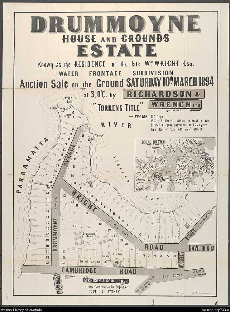
Drummoyne is named after the waterside property of William Wright, a merchant, whaler and sealer, who bought land on the peninsula in 1853. All that remains today is the river wall of Wrights Wharf. The house's gardens included eucalypts, conifers, beds planted with camellias, gardenias and rhododendrons, an orchard, Sydney's largest croquet lawn and a pleasure ground with walks edged in stonework. The estate was first subdivided in 1882 and repeatedly thereafter. The house and shrunken gardens survived until 1971, when the site and its buildings were levelled.

Wright named the property after his family home on the Clyde in Scotland. It is a Gaelic name meaning 'flat-topped ridge'. Aboriginal name: Warrembah, said to mean 'where sweet waters meet'.
Originally part of Surgeon John Harris' Five Dock Farm, Drummoyne grew as a residential area when the main road north was re-directed through it on its way to the original newly built Gladesville Bridge in the 1880s. The south east corner of Drummoyne was subdivided and sold under the name of Birkenhead Estate, thus named after an English town near Liverpool on the Mersey. The name is recalled today in Birkenhead Point. A nearby subdivision to the south of Lyons and Victoria Roads was the Tranmere Estate. A street in the subdivision recalls the name.
Click on or tap an attraction to read the description. Click or tap again to hide the description.

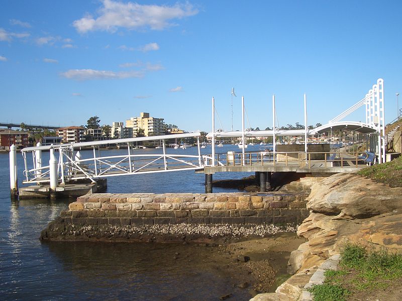
Birkenhead Point is the south eastern point on the Drummoyne peninsula at the entrance to Iron Cove. Its name was first given to the land surrounding the point when it was subdivided in 1854. The name recalls an English town on the Mersey. The area was once largely industrial but it is now the home to Birkenhead Point Outlet Centre, marina and apartment complex. Birkenhead ferry wharf provides access to the area, as well as Victoria Road which has up to twenty bus services from the city to major centres further west.
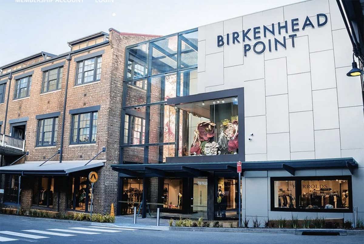
In 1844 a salting and boiling down works was established by Charles Abercrombie. In 1900 the Perdriau Brothers set up a rubber importing company, which, as the automobile began to come into fashion, expanded their operation to manufacture rubber tyres. In 1929 Dunlop took over and by the 1960s, 1,600 employees produced tyres at the plant. In 1977 the plant closed down, and the site was redeveloped into a waterfront shopping centre. In the 1990s apartments were added, and the shops made way for designer clothing brand bargain outlet stores. Recent renovations of the shopping complex started in October 2004, and a new floor and glass roof was completed in November 2010.

It is commonly believed that Iron Cove was named because of the Iron Bridge which spans its mouth. This is not so; it was known as Iron Bark Cove in the 1800s as a forest of iron bark trees surrounded its shores. The current name is a shortened version of the original. Aboriginal name: go-mo-ra.
At the cove's head is Iron Cove Creek (originally called Iron Bark Creek) which supplies water and sediment enriched in copper, lead and zinc to the Iron Cove under low flow conditions. Once a natural watercourse abound with native vegetation and wildlife, Iron Cove Creek was transformed in the late 19th century into a stormwater channel that drains a fairly large catchment area in Sydney's inner-western suburbs. Iron Cove Creek still follows its original course from its source around Norton Street, Croydon though it is but a shadow of its former self. In the 1860s Iron Cove Creek was a freely flowing waterway which in places broadened into ponds that made excellent and picturesque swimming holes. Water birds and snakes were abundant in this area.

The present Iron Cove bridge was opened in 1956 after ten years in construction, its delay caused by a lack of steel after World War II, and ongoing industrial disputes. The bridge replaced an earlier structure which was built and opened in 1882 to complete Sydney's Five Bridges route. Unlike most bridges of its era, the 1882 structure did not end up in the scrap metal yard. Gordon Duff, an enterprising engineer for the Jemalong Shire Council at Forbes purchased the bridge's nine lattice steel spans and had them re-erected across the shire. Five of the spans were used in the construction of the Gordon Duff Bridge. Opened in March 1961, the bridge takes New Grenfell Road over Bundaburrah Creek.
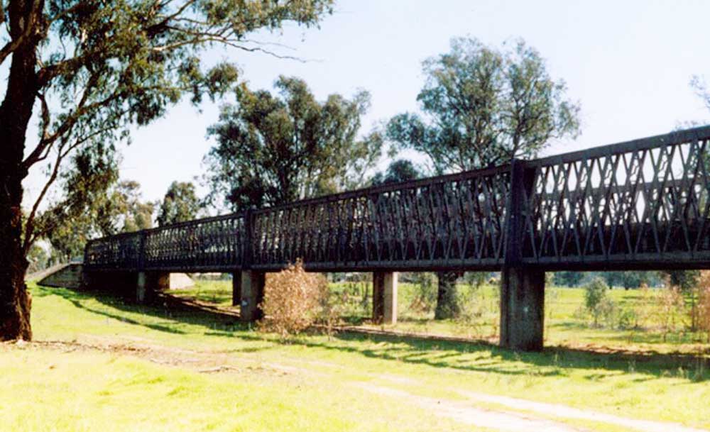
Gordon Fuff Bridge, Forbes
The Iron Cove Bridge is an impressive steel truss bridge consisting of four 18m plate girder approach spans and seven 52m steel Pratt truss spans for a total length of 461.26m. The design of the bridge incorporates many elements of the Inter-War Art Deco style which was at its peak in Australia between 1915 and 1940. It was the last steel truss bridge to be constructed in NSW in which rivets were used for field connections prior to the introduction of high strength bolts. Four lanes of traffic are located within the truss spans. The roadway consists of a 127mm reinforced concrete deck slab with an inset for tram tracks in the centre portion. The Bridge was officially opened by the Hon. J.J. Cahill, MLA, Premier and Colonial Treasurer of NSW on the 30th July, 1955.
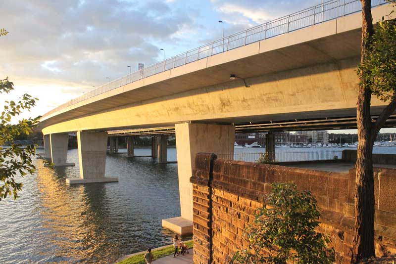
A 2 lane concrete road bridge was built alongside the Iron Cove Bridge in 2011 to alleviate traffic conjection. It is offically called the inner-west busway. Local residents and businesses have opposed the bridge duplication, saying it would and has increased congestion on either side of the bridge and surrounding streets.
Five Dock Bay and Five Dock Point (at the end of Victoria Place) are named after the 1,500 acre farm of Surgeon John Harris' (1754-183) which once covered the whole peninsula. The name is said to refer to five rocky inlets between the Parramatta River and Hen & Chicken Bay.

Drummoyne Avenue leads to Wrights Point where a small park retains steps and a landing place associated with the now-demolished Drummoyne House. Wrights Point is named after white settler William Wright, who once occupied the whole peninsula. Wright was a successful merchant and island trader, born in Colchester, Essex, in 1807. As a teenager he had served an apprenticeship at an ironmongery before making to the move to Australia with his wife Bethia in 1838 to take over his uncle’s trading business in Sydney. The following year Wright organized a trading expedition to New Zealand and in by 1843 had established Wright’s General Commission and Shipping Agency in Auckland.
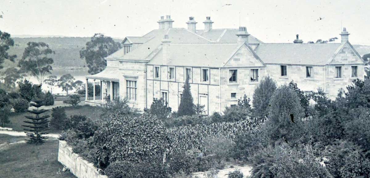
Drummoyne House, 1860
In 1853 Wright retired from commercial life. He settled on land he had bought on the Parramatta River where he began building a substantial and beautiful home. He called the property ‘Drummoyne Park’ after a family estate in the west of Scotland, with ‘drum’ meaning a ‘a ridge’ and ‘moyne’ meaning ‘a plain or marshy flat’ in Scots Gaelic. Wright invested the best of everything he could in his house at Drummoyne Park. It is believed that he employed around 70 European artisans in the building of its steps and balustrades, many of whom had also worked on the grand buildings that were evolving in the area of Hunters Hill. Italian masons were said to be responsible for the wood carvings inside the house, some of which are now in the collection of the Art Gallery of NSW. However it was not just the house that made Drummoyne Park a striking feature of the area, as Wright’s estate was also known for its extensive and beautiful gardens. More

The original Gladesville Bridge, linking Drummoyne to Hunters Hill and Gladesville, was the first road bridge over the main navigable harbour channel and the first permanent regular crossing to the north shore. Opened on 1st February 1881, it was similar in design to the Pyrmont and Glebe Island Bridges, on sandstone piers with 5 iron lattice girders each 46m in length, and a central swing-span. The Gladeville Bridge replaced the Bedlam ferry punt which for 80 years had linked the northern and southern sections of the Great North Road, the main thoroughfare to the Hornsby and Hawkesbury districts from Sydney. Victoria Road became its replacement, leaving the Great North Road to become a road to nowhere.

Being only a two-lane bridge including tram tracks, the swing bridge had become a major bottleneck by the 1950s. Traffic jams and lines of cars queued up to cross became commonplace. In 1960 work commenced on its replacement, the high span concrete bridge we see today. Opened on 2nd October 1964, the great concrete arch was built to a height of 40.8 metres at its centre, which allowed access for large ships travelling upstream, particularly the colliers which serviced the Mortlake Gasworks. Following the shift to natural gas, colliers no longer use this section of the river.

If you pass under Gladesville Bridge on the Parramatta Ferry, you will see the bridge consists of four ribs side by side. Each rib was assembled from precast hollow concrete boxes on falsework right across the river. When a rib was made self-supporting it lifted off the falsework which was then moved sideways for the next rib and so on. The traffic deck is a series of prestressed concrete girders on slender reinforced concrete columns. At completion in 1964 Gladesville Bridge was the largest concrete arch in the world with a span of 305m. It contains 50,000 tonnes of concrete and has a clearance of 37m above high tide.

The neighbouring suburb of Russell Lea sits on the western shore of Iron Cove, on the Parramatta River. Russell Lea was once encompassed in the Five Dock Farm estate of surgeon John Harris. In 1790 this outspoken Irishman arrived in the infant colony, for which he displayed an instant dislike. However his rapid acquisition of Crown land may have served to change his tune. After being appointed court magistrate in 1794, Harris received 45 ha (110 acres) in the Parramatta region which now bears the name Harris Park.
Russell Lea takes its name from one of its original settlers, Russell Barton, who was a pastoralist, mine owner and politician. He developed the "Russell Lea Estate" on a 24-hectare (60-acre) grant. In 1874 he invested in the Cobar mine, eventually rising to serve as its managing director. Displaying much skill in this industry, Barton was soon elected to no less than 11 mining company boards. From 1880 to 1886 Barton served as parliamentary member for Bourke. It was during this time he erected the imposing Victorian Italianate mansion Russell Lea, whose estate occupied the suburb which bears its name. Russell Barton's Russell Lea estate survived intact until 1913, when it was subdivided and auctioned by Hardie and Gorman.

The neighbouring suburb of Chiswick is located 9 kilometres west of the Sydney central business district. Chiswick sits on the peninsula between Abbotsford Bay and Five Dock Bay, on the Parramatta River. It is surrounded by the suburbs of Abbotsford, Russell Lea and Drummoyne. The area around Chiswick was first known by its Aboriginal name Bigi Bigi.
After colonisation, it was originally part of Five Dock Farm. In the 1850s a Dr Fortescue owned an estate in this area which he named Chiswick after the village on the Thames, west of London. Parramatta River had been known as the 'Thames of the Antipodes' and other nearby suburbs were also named after Thames localities of Greenwich, Woolwich, Henley and Putney.
The Chiswick ferry wharf is used by Parramatta River ferry services. State Transit operate a terminus nearby, with buses running to Circular Quay either via Drummoyne and Victoria Road, or via Leichhardt and Parramatta Road. The bus terminus also has a route running to Campsie station via Burwood station. Chiswick has a small group of shops in Blackwall Point Road, close to the ferry wharf.