


Bantry Bay Walks
Bantry Bay is a sheltered bay which has remained somewhat isolated from the rest of the city. Tucked away in a forgotten corner of Middle Harbour, it was deemed the ideal place for the storage of explosives in colonial times. The storage facilities still stand as a reminder of the bay's former use. Today, Bantry Bay is encompassed by Garigal National Park, and it only on foot via its bushwalking tracks that access is gained, unless you come here by boat.The scrubland beyond the head of Banty Bay contains a number of bushwalks of varying difficulties leading to a number of interesting places. The Cook Street Track, which commences from Cook Street, Forestville near the Nursing Home, leads into the upper valley of Bates Creek. The Bay and Magazine Tracks take bushwalkers past three smaller races and falls on the Main Creek.
The Bay Track can be accessed from the eastern shore of Bantry Bay or from the end of Grattan Crescent. When walking the Bay Track you will come across the Natural Bridge Track. The natural rock bridge to which it leads is nestled deep in the valley and takes the track over Main Creek. The track continues up the steep hill to the Bluff Lookout which offers panoramic views south across Bantry Bay. In the valley is a natural bridge, from which one track leads up the hill towards a lookout not far from the Engraving track.

Flat Rock Creek Falls
The Magazine Track leads south along the back of the abandoned Historic Explosives Facility on Bantry Bay itself. At the southern tip of Killarney Heights is a beautiful, secluded bay with a small beach. Behind the beach the waters of Flat Rock Creek tumble down the escarpment in a number of spectacular falls and races before entering the bay at the head of the beach. The beach and the falls behind it can also be accessed via the Flat Rock Walking Track from a track at the end of Killarney Drive and from the Healey Way below the Roseville Bridge which leads south alongside the upper reaches of Middle Harbour.
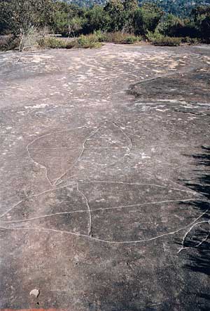
The Engravings Track, which commences at the end of Bantry Bay Rod, Frenchs Forest, leads to one of Sydney's biggest Aboriginal engraving sites with over a hundred figures carved into the flat rock of the plateau.
Click on or tap an attraction to read the description. Click or tap again to hide the description.

These are the most extensive single group of carvings in the Sydney metropolitan area are located on a rocky outcrop on the hillside above Bantry Bay and accessed via the Engravings Track alongside Wakehurst Parkway 400m south of the end of Bantry Bay Road. There are almost 82 figures, including 2 mundoes, people, animals, fish, shields, a canoe, a basket and bag, boomerangs, circles, stone axes and clubs, snakes and a whale.
One group of figures shows two men, one of whom is carrying bark canoes. Other engravings occur in the surrounding bush land but they are not easy to find as they are not marked and often in locations where fallen leaves and other bush debris have covered them. Middens and rock shelters can be seen on the shores of the bay. Tool sharpening grooves have been found near the engravings and creek beds. The engravings are best viewed early morning or around sunset. They have not been maintained or protected from the elements, and now are badly eroded and are difficult to identify in full sun. UBD Map 196 Ref P 1

A 16 metre high waterfall that flows deep in the relatively untouched bushland of Garigal National Park at the northern end of Bantry Bay. Featuring evidence of Aboriginal occupation in the overhangs nearby, the falls are hard to reach these days as a track to the base of them was swallowed up by regenerating bush after a fire swept through the valley in the 1980s. Access, such as it is, is via the Cook Street Track which has entry points in Cook Street and Currie Road, Forestville. The Bay and Magazine Tracks take bushwalkers past three smaller races and falls on the Main Creek. The Bay Track can be accessed from the eastern shore of Bantry Bay or from the end of Grattan Crescent. When walking the Bay Track you will come across the Natural Bridge Track. The natural rock bridge to which it leads is nestled deep in the valley and takes the track over Main Creek. The track continues up the steep hill to the Bluff Lookout which offers panoramic views south across Bantry Bay. UBD Map 176 Ref G 13
When the first fleet of convict settlers arrived in 1788, the area to the north of Bantry Bay was the eastern perimeter of a wide belt of Blue Gum forest which stretched across the whole of the Upper North Shore from Crows Nest to Hornsby and from Castle Hill to Frenchs Forest. This forest was composed of big trees up to 50 metres high, the most common being the Sydney Blue Gum on the lower slopes and in valleys, and Blackbutt which occupied the ridges. Other trees included Angophora costata; Grey Ironbark; Turpentine and Forest Oak. Their timber was considered perfect building material for bridges, buildings and ships and a thriving timber-getting industry soon developed.
A pioneer timbergetter of the area was James Harris French who later gave the suburb of French's Forest its name. French was a Constable and Crown Lands Ranger who arrived in the area in 1856. He acquired 46 acres of land above Bantry Bay and established the first local timber industry.
Access to and from Bantry Bay was mostly by water, but in approximately 1855 a road was cut from Bantry Bay Road to the eastern shore of the bay. It is probable that French used his influence as Crown Lands Ranger to have the road constructed at Government expense. Frenchs sawmill cut and split timber on the hills above the bay and then dragged it down to Bantry Bay by bullock team. From the wharf on the eastern shore it was shipped to the Harbour for sale. Today, the Wakehurst Parkway follows the route of the old road along the top of the ridge. Correspondence from the Secretary for Lands and Public Works in 1856, indicates that a wharf had been erected, probably to serve the saw millers, at the end of the track.
The Old Bullock Track still exists in parts with cobbles, culverts and the remains of a stone bridge, and the reclaimed area at the end of the track is probably the base of the wharf.

At the southern tip of Killarney Heights on Middle Harbour is a beautiful, secluded bay with a small beach that feels as though it is miles from anywhere. On the southern fringe of Garigal National Park, it is one of those places that the essence of can never be fully captured in a photograph. On weekends, families come here for a swim in its calm waters and a clamber over the rocks at the head of the cove, followed by a beach picnic. On weekdays, there is rarely anyone here, so those who do visit generally have the place to themselves.
Flat Rock Creek Falls
Behind the beach the waters of Flat Rock Creek tumble down the escarpment in a number of spectacular falls and races before entering the bay at the head of the beach. Come after rains for the best flows; in the middle of summer the flow can drop to barely a trickle. The beach and the falls behind it can be accessed via the Flat Rock Walking Track from Killarney Point and from the Magazine Track which passes behind the historic Bantry Bay explosives compound.

Access to Flat Rock Bay is by boat or on foot only. If coming by car, park at the end of Killarney Drive and walk down the steep but manageable path to the beach (above). The path is the beginning of the Magazine Track, a management track which continues on towards and then above the western side of Bantry Bay, ending at Cook Street, Forestville. There is no access to the Bantry Bay Explosives Magazine complex, which it passes above.
No facilities. UBD Map 196 Ref K 3

This walk is named after the heritage magazine buildings at about the halfway point. There is not a great view of the buildings but the walk provides great views of Bantry bay. Most of the walk is on a bush track and there are plenty of rocky points along the way to sit and soak up the views.
From the bend in Cook St, Forestville, the Magazine Track follows the management trail. The track leads south along the back of the abandoned Historic Explosives Facility on Bantry Bay itself. At the southern tip of Killarney Heights is a beautiful, secluded bay with a small beach. Behind the beach the waters of Flat Rock Creek tumble down the escarpment in a number of spectacular falls and races before entering the bay at the head of the beach.

The beach and the falls behind it can also be accessed via the Flat Rock Walking Track from a track at the end of Killarney Drive and from the Healey Way below the Roseville Bridge which leads south alongside the upper reaches of Middle Harbour. Length: 3.4 km one way.

The Natural Bridge is a sandstone arch in Garigal National Park. The arch spans an unnamed creek feeding into Bantry Bay. The Natural Bridge track uses this arch to cross the creek, and is not always noticed by walkers as the surrounding vegetation hides the full view of the feature from the track. The arch has formed the eroding forces of water flowing down the creek. The arch provides an interesting natural feature to explore and enjoy.
Starting at Cook Street in Forestville, this walk follows service trails and bush tracks through Garigal National Park, to the Natural Bridge. The walk uses the arch as a natural bridge to cross the creek. The rock formation is the main highlight of this walk, though the wild flower displays in the warmer months can be quite spectacular as well. Length: 1.4 km return.
- Trail notes and map
There is also a longer and more challenging walk that includes a visit to the Natural Bridge, before climbing the hill and continuing to the Bluff, a large rocky point. The Bluff has its own interesting shapes plus a fantastic view down Middle Harbour and across to the city. The walk starts from Currie Rd in Forestville.
When walking the Natural Bridge Track you will come across the Bay Track. The Bay Track leads to either the eastern shore of Bantry Bay or the end of Grattan Crescent, Frenchs Forest. Length: 3.7 km return.

Garigal National Park, which encompasses the upper reaches of Middle Harbour Creek on the northern outskirts of suburban Sydney, features a series of valleys through which creeks trickle and cascade into sparkling rock pools on their way to Sydney Harbour. A maze of fire trails and walking tracks make access easy to all but the most isolated sections of the park. Stepped sandstone ridges guard the valleys and provide numerous vantage points from which to view the forested valleys below.
Location: UBD Map 176 Ref C 6. Garigal National Park Information Centre: (02) 9451 3479.

Ku-Ring-Gai Chase National Park is a wonderful stretch of natural bushland set against the picturesque Hawkesbury Rivers and its tributaries in the north and Sydney's north shore suburbs in the south. It features many riverside picnic spots, extensive bushwalking tracks and some of the finest examples of Aboriginal rock art in the Sydney region.
Location: 7 km north of Pymble, 26 km north of Sydney. Ku-Ring-Gai Chase National Park Information Centre - Asquith and Bobbin Head. Phone (02) 9457 1049. General enquiries for West Head may be made to Garigal National Park on (02 94513479).
Aboriginal rock carvings near the Engravings Track, Allambie
How to get there: by car to the various entry points detailed in the main text. Garigal National Park Information Centre: (02) 9451 3479.
Localities and Attractions